There are places along the Colorado River where the river makes me smile.
There are places where it makes me reach for a fishing rod.
Others make me reach for a camera.
And then there is the final stretch from Yuma, Arizona, through Mexico toward the Gulf of California.
This part makes me stop and think.
I have followed this river in these pages from cold mountain water born high in Colorado's Rocky Mountains. I've watched it gather strength, tumble through canyons, feed reservoirs, support cities, irrigate farms, provide electricity, create fisheries and carry us through some of the most magnificent country in the American Southwest.
Grand Lake.
Glenwood Canyon.
Grand Junction.
Moab.
Canyonlands.
Lake Powell.
Lees Ferry.
The Grand Canyon.
Lake Mead.
Lake Mohave.
Topock Gorge.
Lake Havasu.
Parker.
Martinez Lake.
Yuma.
At almost every stop, the Colorado River has given us something.
Now, standing near Yuma and looking south toward Mexico, I find myself asking a question I never expected to ask about one of America's great rivers:
Where has our precious river gone?
Because under normal modern conditions, the answer is startling.
It has been used.
Not wasted in some simple, careless sense. Much of it has been put to enormously valuable purposes. It grows food. It sustains communities. It fulfills international obligations. It supports an economy and a civilization that earlier generations could scarcely have imagined.
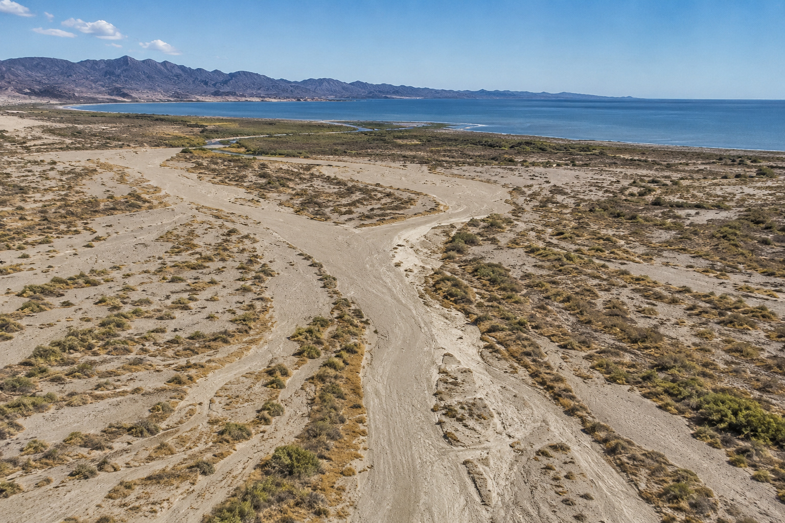
But by the time the Colorado reaches its historic delta in Mexico, there often isn't enough river left to complete the journey nature gave it.
The Colorado River historically emptied into the Gulf of California, also called the Sea of Cortez.
Today it rarely does.
USGS describes the modern reality plainly: dams and diversions throughout the basin have reduced flows so dramatically that the river seldom reaches its terminus in the Gulf. (USGS)
For an old fellow who loves rivers, that is difficult to comprehend.
A river that carved the Grand Canyon can run out of water.
But it can.
And it does.
Leaving Yuma With a Different Kind of Colorado River
Our previous journey brought us down the lower Colorado River from the Parker Strip through Martinez Lake to Yuma.
Yuma is where the story begins changing from recreation and fishing to something much larger.
Water itself becomes the story.
Yuma exists because of the Colorado.
That isn't an exaggeration.
The landscape around Yuma is Sonoran Desert country, naturally hot and exceedingly dry. Yet beside the river lies remarkably productive agricultural land.
That contrast has fascinated me everywhere I've traveled in the Southwest.
Drive across mile after mile of desert, then cross an irrigation canal and suddenly the country turns green.
The transformation looks almost magical.
It isn't.
It's water.
And much of that water came down the Colorado River from mountains hundreds of miles away.
The Colorado River Made Yuma Possible
People were farming along the river around Yuma centuries before modern reclamation projects.
The Quechan people used the river and its floodplain for agriculture long before Europeans arrived. Reclamation's history of the Yuma Project specifically notes that the Quechan had farmed beside the river for centuries using early irrigation practices. (USBR)
That distinction matters to me.
We didn't invent irrigation when engineers arrived with concrete and surveying equipment.
People who lived here before us had already learned one of the Southwest's fundamental truths:
If you can bring water to desert soil, you can grow food.
What modern engineering accomplished was an enormous increase in the scale and reliability of that process.
After passage of the Reclamation Act in 1902, federal water development began transforming the lower Colorado.
The Yuma Project followed.
Laguna Dam was completed in 1909.
The remarkable Colorado River Siphon was completed in 1912.
Imperial Dam followed in 1938.
The All-American Canal became operational in the early 1940s. (USBR)
Those weren't simply construction projects.
They changed the geography of human settlement.
A River Flowing Under a River
One piece of Yuma engineering has always fascinated me.
The Yuma Siphon carries irrigation water beneath the Colorado River.
Think about that for a moment.
Water crossing beneath water.
Constructed in 1912, the siphon remains part of the irrigation system supplying Yuma Valley farmland. Reclamation has described it as continuing to serve tens of thousands of people and more than 50,000 acres of productive farmland. (USBR)
The present Yuma Project routes water through an elaborate system of canals, drains and pumping facilities. The Yuma Main Canal passes beneath the Colorado River through an inverted siphon before water continues into canals serving agricultural lands toward the Mexican border. (USBR)
I admire engineering like that.
I spent enough of my working life around construction to appreciate what earlier generations accomplished without computers, satellite positioning or laser surveying.
But every canal also represents something else.
Water leaving the river.
And from here south, that becomes increasingly important.
Imperial Dam: Where Much of the River Turns Away
If I were looking for one place that visually explains what happens to the lower Colorado River, I'd begin upstream of Yuma at Imperial Dam.
Imperial Diversion Dam was completed in 1938.
Its job is right there in the name.
Diversion.
It diverts Colorado River water into the All-American Canal for California and into the Gila Gravity Main Canal for Arizona. (USBR)
That water doesn't vanish.
It goes somewhere useful.
Fields.
Farms.
Communities.
Irrigation systems.
The Yuma Auxiliary Project, for example, receives Colorado River water diverted at Imperial Dam and distributes it to agricultural land on Yuma Mesa. (USBR)
But if you're standing downstream and thinking strictly in terms of the river itself, something dramatic has happened.
The Colorado has become smaller.
Much smaller.
Agriculture and the Colorado River: A Complicated Relationship
It's easy to look at a dry river channel in Mexico and declare irrigation the villain.
I don't think the story is that simple.
I've lived too close to agriculture for that.
Growing up on cattle ranches in the Kansas Flint Hills taught me early that food doesn't originate in supermarkets. Somewhere there is a farmer or rancher dealing with weather, soil, machinery, animals, markets and a thousand things beyond his control.
Water in the desert creates astonishing agricultural productivity.
Yuma's growing season allows farmers to produce crops during months when much of America is frozen.
That has value.
Enormous value.
But the Colorado River has limits.
That's the uncomfortable part.
We built an agricultural and urban economy around the assumption that we could withdraw extraordinary quantities of water year after year.
Then the climate reminded us that the river keeps its own books.
The Colorado River Was Divided on Paper
The modern Colorado isn't governed only by geography.
It is governed by law, treaties, interstate agreements, operating rules, court decisions and what collectively became known as the Law of the River.
Seven American states depend upon the Colorado:
Colorado.
Wyoming.
Utah.
New Mexico.
Arizona.
Nevada.
California.
And then there is Mexico.
Under the 1944 Water Treaty, the United States is obligated to provide Mexico with 1.5 million acre-feet of Colorado River water annually, subject to treaty provisions including drought conditions. (IBWC)
An acre-foot is roughly the amount of water required to cover one acre one foot deep.
Multiply that by 1.5 million.
That's a lot of water.
Yet even Mexico's share doesn't mean 1.5 million acre-feet flows serenely down the old river channel toward the Gulf.
Mexico also needs water for people and agriculture.
So the river gets diverted again.
Morelos Dam: The River's Last Great Diversion
Just downstream of the international boundary is Morelos Dam.
Mexico constructed the dam in 1950 under provisions of the 1944 treaty.
Its purpose is to divert Colorado River water into Mexico's irrigation system, particularly toward the agricultural Mexicali Valley. (USBR)
And this is where our Colorado River journey takes a heartbreaking turn.
Downstream of Morelos Dam, under normal conditions, very little water continues along the historic channel.
USGS has described the lower river as being progressively depleted by diversions until the remaining water is taken at Morelos Dam, leaving nearly 100 kilometers of historic channel dry under many conditions. (U.S. Geological Survey)
Think about that.
We have followed the river for roughly 1,450 miles.
It survived mountains.
Canyons.
Rapids.
Deserts.
But it cannot survive our plumbing.
Where Has Our Precious River Gone?
The answer isn't one place.
It went to Denver-area water users through transbasin diversions.
It went to farms in Colorado.
It went to Utah.
It went to Wyoming.
It went to New Mexico.
It went to Arizona.
It went to Las Vegas.
It went to Southern California.
It went to farms in the Imperial Valley.
It went to Yuma agriculture.
It went to Mexico.
Some evaporated from enormous reservoirs.
Some seeped into soil.
Some returned to the river.
Some was consumed by crops.
Some came from our faucets.
The river didn't simply disappear at Yuma.
We began taking pieces of it thousands of miles upstream.
By the time the remaining pieces arrive in Mexico, there often isn't enough to make a river anymore.
The Colorado River Delta That Once Was
This is the part of the story I wish I could have seen.
Before the modern dam era, the Colorado River Delta was enormous.
The river carried water and sediment from a drainage basin spanning the Rocky Mountains and much of the Southwest.
Then it reached the low desert near the head of the Gulf of California.
Here the river slowed.
Sediment settled.
Channels shifted.
Wetlands formed.
Marshes spread across the delta.
The river divided and rejoined itself.
Floods rearranged the landscape.
USGS research shows that the Colorado's sediment gradually built an enormous delta that eventually separated the Gulf of California from the inland depression we now associate with the Salton Sink. (U.S. Geological Survey)
That is an extraordinary geological accomplishment.
The Colorado didn't merely flow across this landscape.
It built it.
A River Powerful Enough to Move Its Own Mouth
Old rivers rarely behave politely.
The Colorado certainly didn't.
As sediment accumulated, river channels rose above surrounding terrain.
Eventually a flood would break through a bank.
The river would find another path.
Over geologic time, the Colorado shifted between flowing toward the Gulf of California and toward the Salton depression. (U.S. Geological Survey)
Imagine trying to build a permanent town, railroad or farm beside a river capable of changing its mind about where the ocean was.
That was the old Colorado.
Wild.
Muddy.
Unpredictable.
Dangerous.
And alive.
Ancient People of the Delta
Long before modern international borders divided this country, Indigenous peoples lived with the river and its floods.
The lower Colorado supported communities whose cultures evolved around seasonal water, agriculture, fishing, hunting and travel.
Near Yuma, the Quechan lived along the river.
Farther into the delta, the Cocopah and closely related Indigenous peoples developed intimate relationships with the Colorado's wetlands and floodplain.
To them, the river wasn't scenery.
It wasn't a weekend destination.
It wasn't something viewed from an overlook.
It was the organizing force of life.
Food came from it.
Crops depended upon it.
Transportation followed it.
Wildlife gathered around it.
Villages were tied to it.
And the river's floods weren't necessarily disasters.
Floodwater renewed the soil.
Our modern instinct is to control a river.
Their survival depended upon understanding it.
There is wisdom in that distinction.
When Did the Colorado Stop Reliably Reaching the Sea?
The change occurred gradually as dams and diversions multiplied.
Hoover Dam fundamentally changed downstream hydrology beginning in the 1930s.
Later reservoirs captured additional runoff.
Glen Canyon Dam was completed in 1963.
By the 1960s, according to USGS, streamflow depletion and land conversion had dramatically reduced the Colorado Delta, and the river seldom reached the Gulf of California. (USGS)
That sentence still bothers me.
Seldom reached the Gulf.
A river has a beginning and an end.
At least that's how I learned geography.
The Mississippi reaches the Gulf.
The Columbia reaches the Pacific.
The Rio Grande, when conditions permit, reaches the Gulf.
The Colorado?
We consume so much of it that its connection to the sea has become exceptional rather than ordinary.
Does the Colorado River Ever Reach the Gulf of California?
Yes.
That's an important qualification.
Saying the Colorado never reaches the Gulf would be incorrect.
Exceptional flood years have sent freshwater through the delta and into the Gulf.
USGS scientists documented Colorado River floodwater reaching the sea during major flows in 1993 and 1998, using salinity measurements and biological evidence. (USGS)
So the old river isn't incapable of reaching its destination.
Give it enough water and it remembers the way.
I find something strangely reassuring about that.
2014: When Water Returned to the Delta
One of the most hopeful chapters occurred in 2014.
The United States and Mexico cooperated under Minute 319 of the 1944 Water Treaty to release an experimental pulse of water through Morelos Dam into the dry Colorado River Delta.
Beginning March 23, approximately 105,000 to 106,000 acre-feet was released over roughly eight weeks. (USGS)
For the first time in years, substantial water moved through stretches of old river channel.
Scientists watched what happened.
Water infiltrated the ground.
Native vegetation responded.
Cottonwoods and willows benefited.
Habitat improved.
The river reconnected portions of a landscape that had forgotten regular flowing water.
Reclamation reports that some of the pulse eventually reached the Gulf of California. (USBR)
Imagine being there.
Standing beside a dry channel and hearing water coming.
Not a flash flood.
Not a storm.
A river returning.
A Small Flow Compared With the Colorado of Old
The 2014 pulse was historic.
But perspective matters.
USGS scientists concluded that the pulse was only about five percent of the magnitude and lasted roughly 10 to 15 percent as long as seasonal peak flows typical during the early twentieth century. (USGS)
That tells us how powerful the old Colorado was.
What we celebrated as a remarkable restoration event would once have been a relatively modest episode in the river's natural calendar.
Still, it proved something important.
Give this ecosystem water and parts of it can respond.
Minute 323 and Keeping Part of the Delta Alive
The cooperation didn't end with the 2014 experiment.
Minute 319 was succeeded by Minute 323, which began in 2018 and runs through 2026.
Rather than relying primarily upon another large pulse, environmental water under Minute 323 has been directed toward managed restoration areas where it can support native riparian habitat more efficiently. USGS has continued studying these restoration efforts. (USGS)
That may not create the sweeping delta Aldo Leopold famously described from the early twentieth century.
But cottonwood groves matter.
Willows matter.
Wetlands matter.
Migratory birds matter.
And perhaps most importantly, cooperation matters.
The United States and Mexico share this river.
The river doesn't know where somebody drew the international boundary.
The Gulf of California
Eventually the historic Colorado River channel reaches the northern Gulf of California, between Baja California and mainland Mexico.
This is where mountain snowmelt once met salt water.
What a journey that water had made.
A snowflake could fall in Rocky Mountain National Park.
Melt into a tiny alpine rivulet.
Enter the Colorado.
Pass Grand Lake.
Travel through western Colorado.
Cut across Utah.
Move through canyon country.
Enter Lake Powell.
Pass Glen Canyon Dam.
Travel through the Grand Canyon.
Enter Lake Mead.
Pass Hoover Dam.
Enter Lake Mohave.
Pass Davis Dam.
Flow through Topock Gorge.
Enter Lake Havasu.
Pass Parker Dam.
Flow past Parker.
Reach Imperial Dam.
Pass Yuma.
Cross an international border.
Travel through the delta.
And finally mingle with the Pacific Ocean through the Gulf of California.
That is how the watershed works naturally.
Or did.
Geography Explains Both the Problem and the Miracle
The Colorado River basin is enormous.
But much of the lower basin is desert.
That's the paradox.
The river originates in relatively wet, snowy mountains and then transports water into some of the driest country in North America.
That makes the Colorado extraordinarily valuable.
It also makes demand almost inevitable.
People saw water flowing through desert and naturally thought:
We can use that.
Farmers saw fertile soil.
Cities saw drinking water.
Engineers saw hydroelectric power.
Developers saw communities.
Fishermen like me eventually saw reservoirs full of bass.
Every use made sense by itself.
Stack them all together and the arithmetic changed.
And Now the Reservoirs Are Telling Us Something
This final chapter can't ignore what is happening upstream in 2026.
The Bureau of Reclamation says the Colorado River Basin has experienced 26 years of unprecedented drought, and the winter of 2025-2026 produced record-low snowpack. Combined storage in Lake Powell and Lake Mead has fallen below anything seen since before Lake Powell began filling in 1963. (USBR)
Lake Mead's elevation fell from about 1,062 feet at the beginning of 2026 to roughly 1,039 feet in late August, according to Reclamation's provisional operational data. (USBR)
Those aren't abstract numbers to Paulette and me.
We've spent our winters beside Lake Mohave.
We've watched reservoir shorelines.
We've watched launch ramps.
We've seen bathtub rings on canyon walls.
We've lived through the falling water at Elephant Butte that originally pushed us to look toward Arizona.
A declining reservoir gets my attention.
A declining river gets everybody's attention eventually.
Irrigation Isn't the Whole Story
Agriculture is a major Colorado River user, but I don't want this article reduced to "farmers took the river."
That's too easy.
Cities need water.
Tribes hold important water rights.
Industry needs water.
Wildlife needs water.
Hydroelectric facilities depend upon reservoir elevations.
Recreation has become economically important.
Mexico has treaty rights.
And farms feed people.
The real question isn't whether one group deserves water and another doesn't.
The question is:
How do millions of people share a river whose long-term supply may be smaller than the system we built around it?
That's harder.
But that's the question worth asking.
Water Levels Below Yuma
For travelers expecting to see a substantial free-flowing Colorado all the way from Yuma to the Gulf, the modern geography can be confusing.
The channel continues.
The river does not necessarily continue with it.
Water crossing into Mexico is accounted for under the international treaty. The principal accounting point is at the Northerly International Boundary, and much of Mexico's allocated Colorado water is subsequently diverted at Morelos Dam. (IBWC)
Below there, the historic river channel may contain little or no continuous surface flow.
Some water can come from groundwater, agricultural return flows, restoration deliveries or occasional floods.
But under ordinary modern conditions, don't expect the broad Colorado we've been following upstream.
That's precisely the point of this chapter.
Getting There From Yuma
For an American traveler, Yuma, Arizona, is the logical jumping-off point for understanding the final Colorado River.
Interstate 8 connects Yuma with both Phoenix and Southern California.
The river and international border lie immediately west and south of the city.
The historic Yuma riverfront is an excellent place to begin because it helps explain why this location mattered for thousands of years.
From there, travelers interested in following the river toward Mexico need to understand that crossing an international boundary changes everything.
Passports and current entry requirements apply.
Vehicle insurance requirements differ in Mexico.
Road and security conditions should be checked immediately before travel.
Some delta areas are remote, environmentally sensitive or difficult to access.
I would never simply follow a dirt road on a map because it appears to approach the river.
And I certainly wouldn't cross onto tribal, private, agricultural or protected land without permission.
The delta is best approached as a place to understand, not conquer.
If I Could Stand at the River's Historic Mouth
After following the Colorado all this way, I think about what it would feel like to stand near its historic mouth at the Gulf of California.
I'd bring the camera.
Of course I would.
Probably the tripod too.
Paulette would have her camera.
We'd arrive early.
I would want sunrise.
There would be mudflats and tidal water.
Mountains softened by distance.
Birds working the estuary.
Maybe a little morning haze hanging over the Gulf.
And somewhere inland would be the old channel of the Colorado River.
I'd look north.
That is the direction that would get me.
Because I would know what lies beyond that horizon.
Not simply Yuma.
Everything.
I Remember Where This River Began
I'd remember those headwaters high in Colorado.
Cold water.
Snow.
Mountain meadows.
Trout.
Moose.
Rocky Mountain National Park.
I'd remember the country between Grand Lake and Granby.
The river beside Highway 40.
Kremmling.
Pumphouse.
Radium.
Glenwood Canyon.
Then Grand Junction.
Red rock.
Moab.
The old Western movie country that stirred my imagination as a boy in Kansas.
Canyonlands.
The Green River joining the Colorado.
Lake Powell.
Lees Ferry.
The Grand Canyon.
Lake Mead.
Lake Mohave.
Our winter home.
Topock Gorge.
Lake Havasu.
Parker.
Martinez Lake.
Yuma.
What a river.
What a journey.
And then I'd turn toward the historic river channel and ask again:
Where has our precious river gone?
The Answer Is All Around Us
Maybe that's the lesson.
The river isn't simply gone.
It's in a lettuce field near Yuma.
It's in a canal crossing the desert.
It's in a glass of water in Las Vegas.
It's in a California kitchen.
It's in an Arizona neighborhood.
It's in an alfalfa field.
It's in tribal communities whose relationship with this river predates the United States.
It's in Mexican agriculture.
It's behind Hoover Dam.
It's behind Glen Canyon Dam.
It's in Lake Havasu.
It's in Lake Mohave.
It's evaporating beneath desert sunshine.
It's supporting cottonwoods planted in a restored section of delta.
The Colorado River has been spread across the Southwest.
Perhaps too thinly.
What an Old Outdoorsman Sees
I've spent most of my life outdoors.
Ranch country.
Lakes.
Rivers.
Mountains.
Deserts.
I've flown over them.
Fished them.
Photographed them.
Written about them.
And one thing age teaches you is that permanence is largely an illusion.
Mountains erode.
Lakes rise and fall.
Forests burn and return.
Rivers change course.
People come and go.
But I've also learned that some changes are ours.
The Colorado River Delta didn't dry simply because rivers naturally come and go.
We changed the river.
We dammed it.
Stored it.
Diverted it.
Straightened parts of it.
Allocated it.
Irrigated with it.
Built cities with it.
And benefited enormously from it.
I have benefited from it personally.
I can't write lovingly about fishing Lake Mohave, Lake Mead and Lake Havasu without acknowledging that those reservoirs exist because we changed the Colorado.
That's the uncomfortable balance.
I treasure what we created.
And I mourn some of what we lost.
Both can be true.
The Colorado River Is Not Finished
The story doesn't have to end with an empty channel.
The 2014 pulse flow demonstrated that water can revive portions of the delta.
Later restoration efforts demonstrated that carefully targeted environmental water can support cottonwood, willow and riparian habitat. (USGS)
Nobody seriously expects to dismantle the modern Southwest and return the Colorado completely to its nineteenth-century condition.
Nor should we pretend millions of people and productive farms don't exist.
The challenge is more practical.
Use less where we can.
Waste less.
Improve irrigation efficiency where it genuinely saves consumptive use.
Recycle urban water.
Protect critical habitat.
Respect tribal water rights.
Honor international commitments.
Manage reservoirs based upon the river we actually have rather than the river we wish we had.
And somehow reserve a little water for the river itself.
That last one seems important.
A River Should Be Allowed to Be a River
After 1,450 miles, I keep coming back to that simple thought.
A river isn't merely a pipeline.
It's habitat.
History.
Geology.
Culture.
Wildlife.
Recreation.
Agriculture.
Memory.
It's cottonwoods and cattails.
Trout in cold mountain water.
Smallmouth beneath desert rock.
Largemouth hiding in Martinez Lake reeds.
Moose browsing beside its headwaters.
Bighorn sheep watching it from canyon walls.
Herons stalking its shallows.
People who have lived beside it for thousands of years.
And two old travelers named Pat and Paulette following it with fishing rods and cameras because we can't resist seeing what's around the next bend.
The Colorado River gave the American Southwest far more than water.
It gave the Southwest part of its identity.
Where Has Our Precious River Gone?
So perhaps my title deserves an answer.
Where has our precious Colorado River gone?
Everywhere.
That's the problem.
And perhaps, in that answer, there's also hope.
Because if human decisions helped diminish the delta, human decisions can preserve parts of it.
We cannot recreate yesterday.
I wouldn't pretend we can.
But we can decide what tomorrow looks like.
I'd like to think that somewhere far beyond my lifetime, an old fisherman might stand beside the Colorado River Delta with his wife.
Maybe he'll have some sort of camera I couldn't begin to understand.
He'll point it toward a stand of cottonwoods.
A bird will lift from the river.
He'll hear moving water.
And perhaps he'll tell his wife:
"You know, there was a time when people thought this river might disappear before it ever reached the sea."
Then they'll stand quietly and watch the Colorado River meet the Gulf of California.
I'd like that ending.
After everything this magnificent river has given us, I think it deserves one.
0 Comments